
Projects (as principal investigator)

This graph is from Dr. Carpintero's thesis:
Semiarid rangelands (grasslands with scattered trees and shrubs) are one of Africa’s most complex and variable biomes. They are a mosaic of land uses, where extensive livestock is the main economic activity, and agriculture, soil for livelihood, or conservational uses are also crucial. They are highly controlled by the availability of water, e.g., pasture and rainfed crop production. Although the vegetation is adapted to variable climatic conditions and dry periods, the increase in drought intensity, duration, and frequency, changes in agricultural practices, and other socioeconomic and environmental factors precipitate their degradation.
By integrating Earth Observation data into models, we can evaluate, on the one hand, the water consumed by semiarid ecosystems and their vegetation water stress and, on the other, its primary production. Thus, it allows us to assess both processes’ interactions, improving our knowledge about the vegetation’s behavior in the face of drought. TACTIC will map water consumption and primary production of semiarid mosaic crop rangelands at the optimal spatio-temporal scales, setting up an open-source cloud framework to monitor these processes’ interaction in the long term and analyze system tipping points.
This information can reduce the uncertainty associated with the administration and farmers’ decision-making processes.
SWATCH (H2020-MSCA-IF-2015-703978)
Results
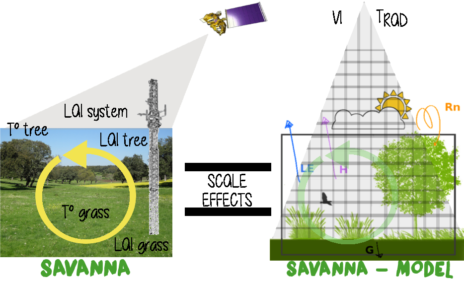
Savannas are among Earth’s most complex, variable, and extensive agrosilvopastoral systems. One-fifth of the world’s population depends upon them (e.g., livestock, rural livelihoods). Droughts and erratic rainfall patterns across the globe result in water-limited environments sensitive to climatic conditions, environmental changes, and land management practices, jeopardizing the ecosystem’s productivity and resilience.
The aim of SWATCH was, then, to develop an information system for quantifying savanna water use and biomass production on a regional scale, with the ultimate objective of supporting decision-making processes.

The Earth Observation data provided by Sentinel 2’s and Sentinel 3’s missions from the European Space Agency will allow us to map the water use and stress across the African savannas and monitor seasonal and long-term temporal variations in a semi-continuous spatiotemporal way. For this, this project integrates two ET-estimation approaches with different conceptual and operational capabilities and limitations.
Kc-FAO56 (Allen et al. 1998), combining reflectance-based “crop” coefficients, is used to derive unstressed savanna evapotranspiration (with high spatial resolution). The two-source surface energy balance model (TSEB) (Norman, Kustas, and Humes 1995) integrating radiometric surface temperature allows the determination of water stress across savannas (with low spatial resolution).